Tag: metashape

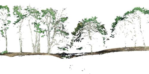
3D point cloud of the 1000 years old Ivenacker Oack Trees

Its always a challenge to work on vegetation point cloud renderings with multi view image matching concepts. In complex 3-dimensional environments and for horizontal image capturing – using a drone is often just not possible. Here horizontal imaging can be an affordable alternative to TLS (Terrestrial Lidar Scanning) systems. Drawback of most OTS consumer electronics camera systems is the missing...

Oblique and cross-grid UAV imaging flight plans – a sneak preview of the analysis of resulting 3D point cloud properties for deciduous forest surfaces – low cost 3D mapping with the Phantom 4R (RTK)

Flight plans / photogrammetry / structure from motion / Metashape / oblique imaging / 3D point clouds / Lastools / Phantom 4R RTK / beech tree / deciduous trees / forest stand structure “Oblique and cross-grid UAV imaging flight plans – a sneak preview of the analysis of resulting 3D point cloud properties for deciduous forest surfaces” by Sören Hese....

Apple M4Max and M1Max 24C and 32C and Agisoft Metashape – a Performance Surprise (Updated)

Update: 20.10.2025: added the 40C M4Max performance comparison – 16Inch with 128GB RAM Update: 5.4.2022: added the 32C performance of the MBP21 16Inch with 64GB RAM Short update to the benchmark analysis I did with the M4Max and Agisoft Metashape. The M4Max halves the processing time of the M1Max. Here the numbers (this time based on Metashape 2.2.2 … I...