March 31, 2026
Micasense Altum-PT Data Capturing and Processing – the Park3D Project
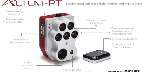
Another report from the Park3D project in cooperation with SPSG (Stiftung Preußische Schlösser & Gärten). Using multispectral cameras on UAV platforms has been not so straight forward in the past and the situation hasn’t changed much. If you are used to the Mavic 3 Multispectral RTK or the Phantom 4 Multispectral RTK systems than the integrated way how DJI managed...