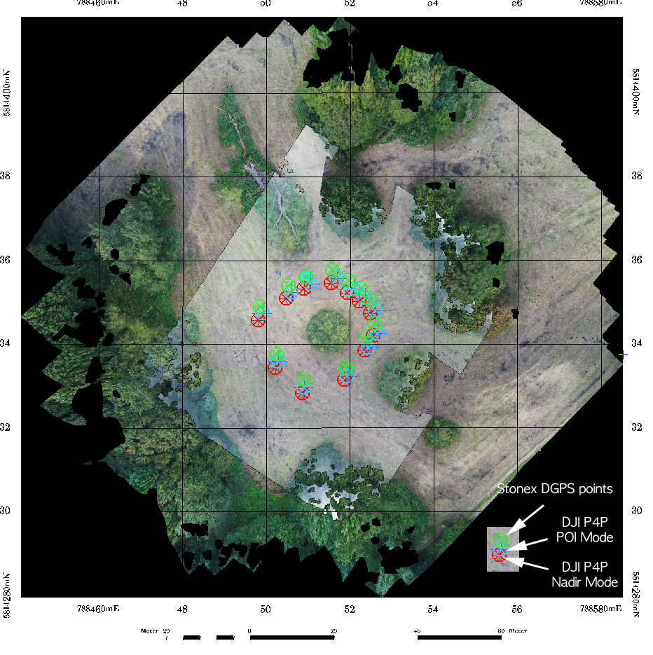
September 27, 2017 The ICAO legend For those not too familiar with the ICAO maps – its nice to have this overview at hand sometimes: The full PDF is available here: https://www.flightplanner.de/legenden/ICAO-D.htm Categories Uncategorized
September 26, 2017 “DJI GS Pro” – Ground Station Testing Some tests using the DJI GS Pro (Ground Station) software for automatic flight programming with the Phantom 4 Pro. New flight campaign at the Kuckenburg spot (Sachsen-Anhalt) finished with two different flight altitudes using DJI GS Pro – mapping the open archaeological excavation site of medieval church now in September 2017. This worked flawless – the only problem: you kind... Categories Archaeology/Quadrocopter/Software/Workflow
September 5, 2017 Paper Download from the UAV-g opened For those interested: the UAV-g in Bonn – that started this week – has all contributions as downloadable PDFs online here: Sessions Categories General/News
September 4, 2017 3D Point Cloud Mapping for Archaeological Applications 3D Point Cloud Mapping for Archaeological Applications Categories Agisoft/Archaeology/Phantom/Point Clouds
June 15, 2017 Erste Lehrbefliegung für den BSc Geographie Lehrbefliegung für GEO214 Categories Point Clouds/Quadrocopter/Teaching
April 20, 2017 “Geo409 Data Exploration” concept – UAV update GEO409 Data Exploration in Remote Sensing Categories Uncategorized
April 10, 2017 New UAV regulations in place and active The new UAV regulations are now active in Germany! For commerical and research flights things are more simple now for copters below 2kg. There is now a general allowance in place for the full federal region of Germany for UAVs below 2 kg (with the restricted regions as listed in the regulations). For copters with more weight a specific training... Categories Quadrocopter
April 1, 2017 Speeding up Agisoft Photoscan For some of the copter data processing folks Agisoft Photoscan turns out to be the most important tool to calculate point clouds, orthoimages and nadir data mosaics. Problem: very long processing times with dense point cloud calculations with high or ultra-high settings (full resolution image matching with SfM (Structure from Motion) algorithms). Some nice net finds show how multicore processing... Categories Agisoft/Point Clouds/Software/Workflow
March 29, 2017 MicroSD cards and standards … There is a lot of confusion about the speed of MicroSD cards these days and various standards exist. Overall its easy to buy yourself into the wrong card type and for copter data acquisitions with the P4Pro the card speed is essential. So here we go: UHS-I and UHS-II (Ultra High Speed Classes): UHS-II is the newest standard but is... Categories News/Workflow
March 27, 2017 Using DroneDeploy and the POI mode for automatic point cloud mapping Using DroneDeploy and the POI mode of DJI. Have been doing some leaf-off flights now in March on one of my favorite sites for complex tree crown point cloud mapping. To add to the leaf-on data from last autumn. Fig.: Leaf-Off point cloud with combined height color coding and reflectance color coding. This time I also checked the full automatic flight... Categories Point Clouds/Software/Workflow